Posted 20 December 2022

The big ones

Like the bogeyman lurking in the basement in a horror movie, the next big earthquake hides in our collective conscious – too scary to consider for many. Earthquakes are unpredictable and scary and the impacts of significant past earthquakes are etched into our history. But there is no avoiding it, we live on shaky islands – New Zealand records an average of 20,000 earthquakes each year – and the more we know, the better prepared we can be for the next ‘Big One’, whenever and wherever it comes. So, let’s take a deep breath, head down to the basement and turn on the lights to see what’s really there…

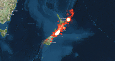
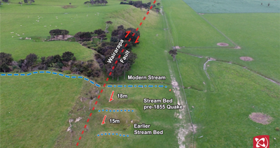
What is ‘Big’ anyway?

There are two main ways to measure earthquakes: magnitude and intensity. Magnitude describes the amount of energy released and is useful for comparing events across time and space because each earthquake has one unique measure of magnitude. However, intensity tells us about the shaking and damage caused by an earthquake, which is what really matters to us mere mortals (Read more about it in How to Measure a Quake – Part 1).

Magnitude has a big influence on the intensity of an earthquake and the severity of its impacts, each step up the magnitude scale represents 32 times more energy released!

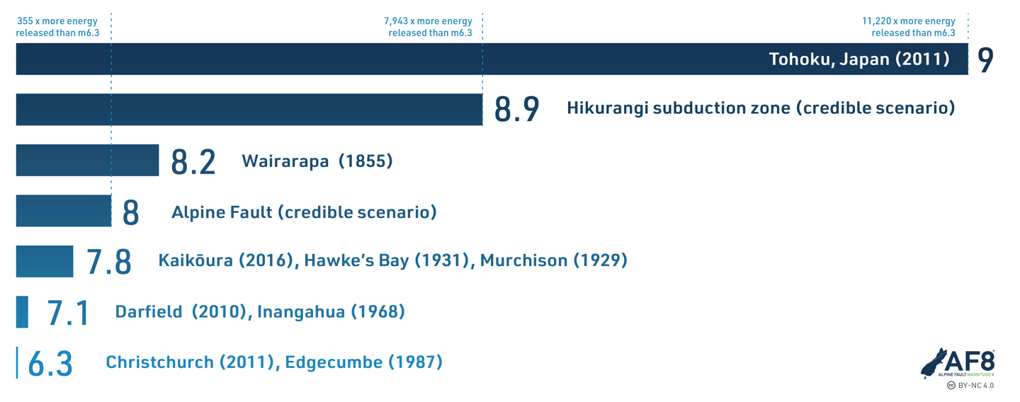
The Magnitude scale is logarithmic so a little magnitude increase equals a massive energy increase. This means that a magnitude 8 earthquake (Alpine Fault) releases 355 times more energy than a magnitude 6.3 earthquake (like the 2011 Christchurch earthquake)! Source: AF8

But when it comes to impacts, the magnitude of an earthquake isn't the only factor, here are some others: 

Depth – earthquakes can occur anywhere from the surface to 700km deep. The shallower the earthquake the closer it is to us on the surface and so the more intense the shaking.

Ground conditions – different ground conditions (rock and soil types) react to shaking differently, e.g. soft sediments can experience liquefaction.

Building Construction – with every earthquake, something new is learned by engineers and building designers about how they will react to a quake and this is translated into the New Zealand Building code.

Time – the time of day and time of year an earthquake takes place can impact the number of casualties, damage and ongoing effects. In winter, for example, woodfires can create a hazardous situation during an earthquake and hypothermia becomes a greater risk for those with limited shelter in the aftermath.

Secondary hazards – Landslides, tsunami, liquefaction, aftershocks, fire and rockfall are common secondary hazards associated with large earthquakes.

Location – Obviously, the more remote an earthquake, the fewer impacts for people. A very large earthquake in Fiordland would hardly be noticed beyond Te Anau and surrounding settlements, whereas a much moderate one in Wellington would have serious implications for a much bigger population and the condensed urban environment.

So a shallow magnitude 6 earthquake in a very populated area could be more damaging than a more remote magnitude 7 earthquake. However, while a lower magnitude quake can cause a lot of damage, a magnitude 7+ quake near a town or city is almost certain to have significant impacts, and a magnitude 8+ will cause damage over a wider area – these are the really big ones.

Past big ones

The largest earthquake ever recorded in New Zealand was the magnitude 8.2 quake on the Wairarapa Fault in January 1855. Some of the land around Wellington was uplifted by 6.4m and in other places it moved 18m horizontally. This was an event of international significance – before this we didn’t know that earthquakes caused shifts of the landscape! This earthquake also caused a tsunami in Cook Strait, which inundated many buildings around Wellington Harbour.

Our little islands have experienced many large earthquakes in the past. Māori oral history includes many references to the shaking of Papatuānuku, and there is a wealth of geological evidence that reveals when some of our big ones occurred (including the last rupture of the Alpine Fault in 1717). While earthquakes have been around for as long as New Zealand has existed, the human impacts have increased over the last 200 years with increased urbanisation and population. Most casualties in earthquakes are from building collapse and/or fire.

The map below shows the most significant quakes recorded since 1848, many of which will be familiar to you. The good news is that each big earthquake increases our understanding of the inner workings of our landscape and how best to prepare for the next one. 


While New Zealand experiences about 20,000 earthquakes every year, thankfully most of them are small. Since records began in 1848, these are the notable earthquakes that have occurred around the country - how many are you aware of? Adapted from: GNS Science

Our twisted plate boundary – the ‘where’

Around the world, earthquakes are concentrated on tectonic plate boundaries and New Zealand sits right on top of part of the boundary between the Australian and Pacific plates – it’s why we have all those lovely mountains and hot pools. This is a complicated boundary and the different ways in which the plates converge along its length, pushed under or moving alongside each other, result in a variety of earthquake types.

The phenomenon of one tectonic plate being pushed under another is called ‘subduction’ and New Zealand’s plate boundary has two areas where this occurs – the Hikurangi Trench (offshore to the north-east of the North Island) and the Puysegur Trench (offshore to the south-west of the South Island). The Hikurangi trench also joins up with the Kermadec Trench further north. Between these subduction zones, in the South Island, there is a massive link structure known as the Alpine Fault. Together with a series of faults through the Marlborough region, the Alpine Fault marks the on-land part of New Zealand’s plate boundary and involves a combination of mostly sidewards movement, but also some squeezing across the island to uplift the Southern Alps.

Aotearoa New Zealand sits astride a complex part of the boundary between the Pacific and Australian tectonic plates that can be divided into three distinct sections. To the north the boundary is marked by the Hikurangi Trench, in the middle (on-land) we have the Alpine Fault and to the south it is marked by the Puysegur Trench. Source: AF8

New Zealand’s plate boundary has a complicated twist – in the north at the Hikurangi Trench, the Pacific Plate is moving under the Australian Plate, whereas in the south at the Puysegar, it’s the opposite!

Geoscience educator Julian Thomson explains more about the complicated tectonic plate boundary we live on. Source: Out There Learning

Shallow vs Deep

All parts of the plate boundary have experienced magnitude 8+ earthquakes in the past but decades of study have uncovered a few other patterns. The two maps at right show shallow and deep earthquakes over the last 10 years in New Zealand. Shallow earthquakes occur along the whole length of the plate boundary, but deeper earthquakes are associated with the subduction zones – so there aren’t many in the centre of the country, along the Alpine Fault.

By comparing the location of deep and shallow earthquakes throughout New Zealand over the last ten years, a clear picture of our tectonic plate boundary and its associated subduction zone appears – its where all the action happens! Source: GNS Science

When will it happen?

By focusing research along the plate boundary scientists are learning more all the time about where the next big one might happen. So now lets take a look at what we know about the when, and thats based on looking at the pattern of what has happened in the past. 

The Good news: really big and damaging earthquakes don’t happen very often. While GNS Science locates an average of 20,000 earthquakes in New Zealand each year, only about 100-150 are large enough to be felt - the rest are only perceptible to seismometers. 

The Bad news:  we didn’t have a magnitude 8 earthquake last century. In fact, the last magnitude 8 earthquake was New Zealand’s largest in 1855 on the Wairarapa Fault (part of the Hikurangi subduction zone). Before that, there was one in 1826 in Fiordland (part of the Puysegur Trench subduction zone) and in 1717 on the Alpine Fault.

The Hikurangi Subduction Zone and the Alpine Fault represent the two biggest sections of our plate boundary. Let's take a look at what we know about when a big earthquake is likely to occur on each.

The Alpine Fault is the South Island’s most significant natural hazard. Scientists now have records going back about 8000 years on this fault and movement seems to be fairly consistent in both size and frequency. The latest research puts the probability of a magnitude 8+ earthquake on the Alpine Fault in the next 50 years at 75%. That’s extremely high!

The Hikurangi Subduction Zone represents an even bigger hazard to New Zealand than the Alpine Fault. However, because it under water and harder to get to, there is a lot less known about this subduction zone. The latest research and data available now indicate the probability of an earthquake of a large earthquake on the southern end of the Hikurangi Subduction Zone in the next 50 years is about 25%.

Research is ongoing and these probabilities will continue to be refined and updated over time as new evidence and data becomes available, but what we know now is pretty startling anyway. There is a pretty high chance that New Zealand will experience a magnitude 8+ earthquake on either the Alpine Fault or the Hikurangi Subduction Zone in the next 50 years.

Scary stuff: what can we do about it?

While it can be scary and overwhelming to think about the next big earthquake, we have learnt a lot from past events and we can use that to help us prepare for the next one. A bit of preparation now will make all the difference to your comfort and resilience when it happens.

The good news is that preparing for a challenging natural disaster like a big earthquake also prepares us for the smaller ones. Have a think about how you would look after your loved ones, neighbours and pets if you were cut off for a few days or even weeks after a big earthquake. Preparedness looks different for everyone and working as a community is the most effective approach overall.

You’ve actually already started, the first step to being better prepared for natural hazards is learning about them. The next step is to put your learning into action, see if you can find a small action to do and then share it with a friend – maybe together you will be brave enough to see what’s really in the basement!


This article is a part of series developed in collaboration with Bounce Insurance, aimed at explaining earthquake science and increasing understanding of earthquake risk and resilience. With thanks to our science partners for their contributions: QuakeCoRE: New Zealand Centre for Earthquake ResilienceResilience to Nature’s Challenges, University of Otago and GNS Science.

Author: Jenny Chandler, AF8 Research Assistant.

Cover image: © GNS Science / Lloyd Homer

Start typing and press Enter to search