Posted 10 January 2023

Earthquake Detectives: How do geologists know about past earthquakes?

Our Earth is a constantly changing and evolving beast shaped over millions of years by tectonic forces – like earthquakes and volcanoes – and weather. Like our bodies, the events of its long life leave scars and wrinkles, fractures, and wounds at every scale from the mighty mountain ranges to microscopic mineral structures.   

All of this is evidence to a keen geological eye. A geologist is like a detective, looking for clues and evidence in the here and now to figure out what happened in the past. The difference is a geologist’s timeframe is in hundreds, thousands and millions of years – the ultimate cold case! 

Evidence in the land

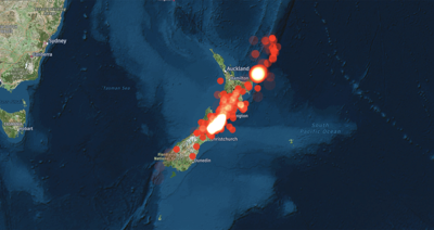
When a large earthquake happens, there is often significant land movement – up, down and sideways. We saw this recently in the 2016 Kaikōura earthquake, where the seabed was uplifted up to 5m along 110km of coastline, leaving paua and crayfish floundering (excuse the pun) in the sun.

At first, this newly exposed rock was white and obviously different, but over time it has begun to weather and gain a disguising crust of barnacles, mussels and bird poo so that to an unknowing eye it already looks like it has always been there. To our geologist detective however, their keen eye can spot these anomalies in the wider landscape and use them to date past events such as this.

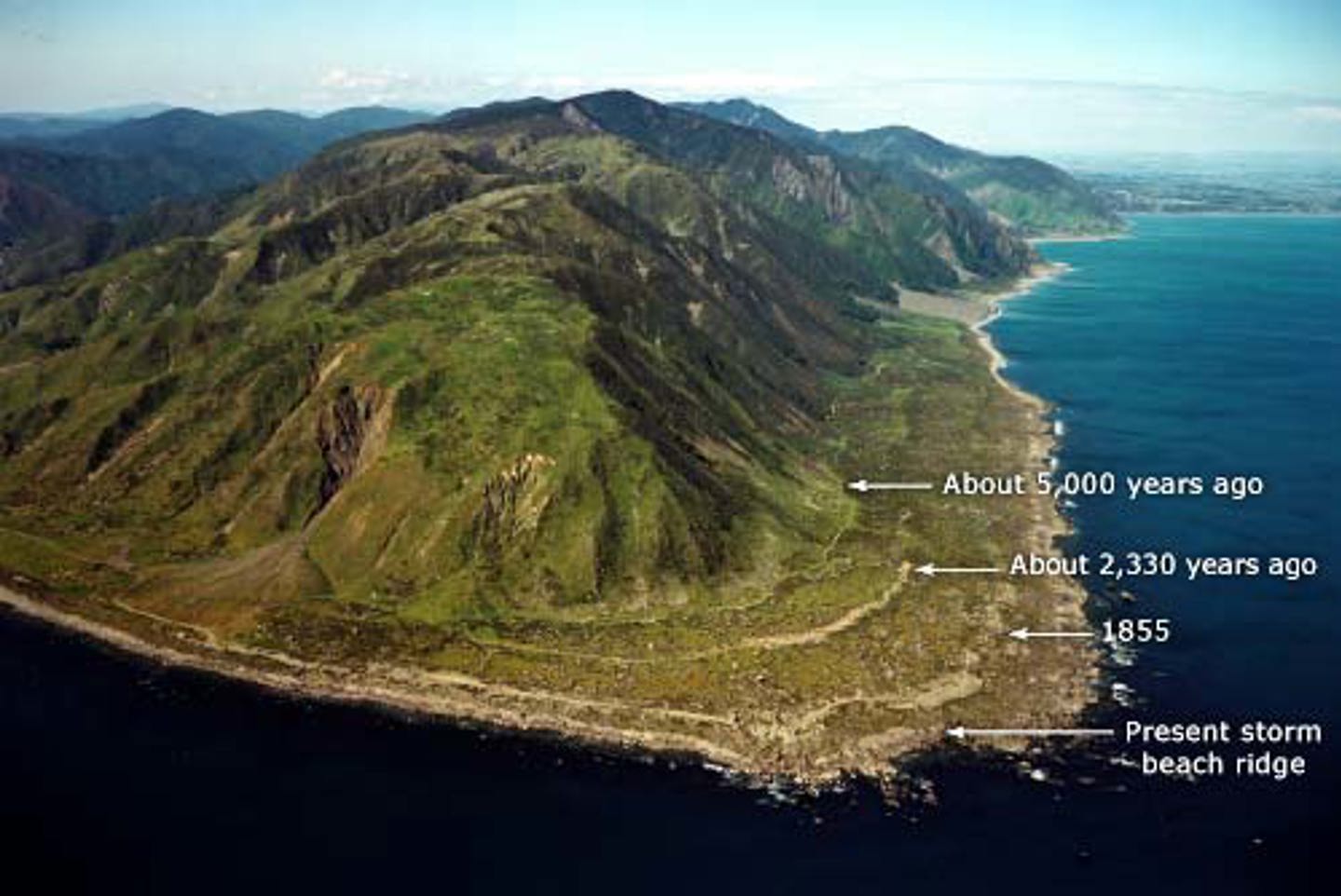
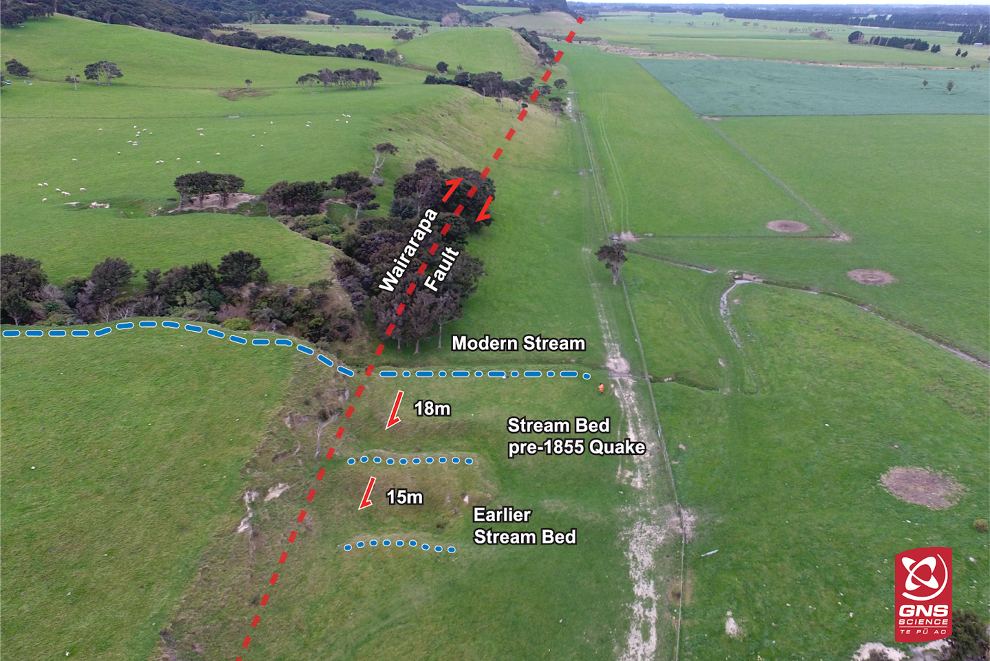
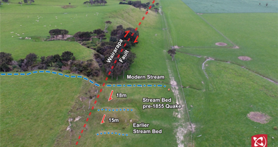
Uplift is one of the ways that scientists have dated past events on the Wairarapa Fault. The magnitude 8.2 earthquake on this fault in 1855 uplifted the land around Wellington by 6.4m. At Cape Turakirae, they observed a series of raised beach platforms, and concluded that this wasn’t the first time the Wairarapa Fault had behaved like this.

Once you know what you are looking for, these old uplift terraces are easily seen from an aerial photo. Over a long, long time this uplift has built the mountains behind these historic beaches. It’s amazing what you can accomplish when you’ve got millions of years to do it! Major faults are also visible in the landscape as linear features – the Alpine Fault is visible from space. While this doesn’t necessarily give scientists information about the earthquakes themselves, it does tell them where to go and look for evidence. 

Water in the landscape gives clues as well. Scientists look for evidence of fault movement where a creek or river crosses it. When there is movement on the fault, the river’s course will be disturbed or even dammed and there may be evidence of this in the landscape. Below is a great example of this from the Wairarapa Fault. Every time the fault ruptures, the old creek bed is left ‘high and dry’ and a new one cuts into the land. Measuring between the abandoned channels and the current creek gives a good idea of the horizontal movement of each event.

A series of raised beaches at Turakirae head, near Wellington, present evidence of periodic uplift, including a terrace inland from the current beach, raised 6.4m in the 1855 Wairarapa earthquake. Source: Te Ara / GNS Science

Where a creek cuts across a fault, evidence of movement on that fault is captured in the landscape by old, displaced creek beds, such as this one in Wairarapa. Source: Andrew Boyes, GNS Science / Out There Learning

Rockfall, landslides and tsunamis caused by earthquakes may also leave records in the landscape, but these can be harder to isolate from other causes such as weather events. It’s great when evidence is right there on the surface, but that is not often the case. The surface of the earth is incredibly dynamic and changeable, and evidence of past earthquakes often ends up eroded, destroyed, or buried.

Evidence underground

Sometimes, erosion (by a river, or sea or slip) will expose a section of fault, but if not, scientists can dig – a process called trenching. They identify a trace of the fault in the landscape and then dig a trench across it to get a 3D view of the fault. They are looking for layers of the same type of rock or sediment that are displaced across the fault.  By measuring the displacement and dating the rock, scientists can identify the age of this past earthquake – another clue in building up a picture of the life of the fault.

Earthquake Geologist Dr Rob Langridge, GNS Science, explains what his team are looking for in trenches dug along the Alpine Fault in Lewis Pass. Source: GNS Science

As well as offset layers, any clues that can exist above ground can be buried and preserved underground such as ancient creek displacement, ancient rockfalls and landslides. As with other detective work, one piece of evidence is rarely enough to tell the story on its own, but it adds another little piece to the jigsaw.

Earthquake forensics

Finding evidence for when something happened is key in any investigation and for earthquake detectives one of the most important tools is radiocarbon dating. When an earthquake happens, living material on the surface (like plants or animals) may be buried and preserved. If scientists can collect some of that material they can use radiocarbon dating to determine its age – and the date of the earthquake!

Trenching is one way of accessing this buried material, (and sometimes it is exposed naturally through erosion), but another really great source is lake sediments. In normal times, sediments build up slowly at the bottom of a lake (that silty mud you sometimes have to wade through for a swim), but when a large earthquake happens, a lot of new material arrives all at once. Drilled samples from lakes near to the Alpine Fault allow scientists to get samples of material that was buried in various Alpine Fault earthquakes.

Geologist Dr Jamie Howarth, Victoria University Wellington, explains how lake sediments taken from Lake Christabel, in the Southern Alps, were used to date previous Alpine Fault earthquakes. Source: GNS Science

Radiocarbon dating relies on the fact that all living things are naturally radioactive – yes even you! When alive, all living things absorb carbon (through food and water) and the different isotopes (carbon 12, 13 and 14) exist in set ratios within the organism. As soon as that organism dies (and stops absorbing carbon) one of those isotopes, carbon 14, starts to decay. By measuring the amount of each isotope in these buried samples, (and doing some complicated calculations) scientists can work out when that organism died. You can learn more HERE

Evidence in the trees

Anything that is affected by an earthquake and preserved can hold useful evidence, long-lived trees are one example. I’m sure you are familiar with tree rings – the annual growth cycles of a tree that show up in a cross-section of their trunk – well believe it or not, they can be another piece of evidence for past earthquakes. By the way, the science of dating events based on tree ring growth is called dendrochronology – word of the day?

Because the disturbance of an earthquake can cause a poor growing season for a tree, the observation of disturbed tree growth can be really helpful in narrowing down timeframes for past earthquakes.  Of course there are many other things that could cause a poor growing season (such as drought) but when observed across a large area and in combination with other clues, tree rings can be an important piece of supporting evidence. In New Zealand, the date of the last Alpine Fault earthquake was narrowed down to 1717 through observing disturbance to the growing cycle of trees in samples from native trees growing near the Alpine Fault. And don’t worry the trees don’t have to be cut down to see the rings, scientists drill a core sample, and the tree carries on its long life. Read more about the research HERE

Evidence in the stories

Large earthquakes can have extremely far-reaching observable effects, and many are recorded in oral and written histories around the world. In 1997, researchers in the Pacific Northwest of North America found evidence of cataclysmic forest collapse. They were able to date the event with radiocarbon dating and fossilized tree rings and used those dates (winter 1700) to look for other records that could give a clue to the cause. They found written records in Japan of a large tsunami that arrived from that direction in January 1700 and concluded that both events were most likely caused by a major earthquake on the Cascadia fault! (read more here)

In New Zealand, physical evidence of past earthquakes can sometimes be linked to those described in Māori pūrākau, or oral history. For example, Māori traditions mention a large earthquake called Hao-whenua (the earth-swallower) that caused major uplift and tsunami in the Wellington region. In 2015, scientists found evidence of old tsunami deposits in lagoons in Marlborough and Golden Bay. They believe that the most recent of these (dated at 1430-1480AD) may be linked to the Hao-whenua event. This was also the event that created the Miramar peninsula, previously an island – see the image below which shows what Wellington would have looked like before the quake (current day shoreline in white dots). Read more here. There is still much opportunity in New Zealand for linking the pūrākau of the past hazard events with new physical evidence.

This aerial image has been modified to show what the shoreline of Wellington harbour would have been like before Hao Whenua (current shoreline is the white dots). What is now the Miramar peninsula was an island called Motukairangi. Source: Te Ara / GNS Science

Solving the case

Like in any good cold case, even a seemingly insignificant piece of information can turn out to be the key that unlocks the whole puzzle. A good detective will look at the information available and identify gaps then get creative about how to find that information. And that is exactly what our geologists do, using all the tools at their disposal to gather more evidence and slowly build a more comprehensive picture of the earthquake history of our islands. This investigation is a long one though and it may never be fully ‘solved’.


This article is a part of series developed in collaboration with Bounce Insurance, aimed at explaining earthquake science and increasing understanding of earthquake risk and resilience. With thanks to our science partners for their contributions: QuakeCoRE: New Zealand Centre for Earthquake ResilienceResilience to Nature’s Challenges, University of Otago and GNS Science.

Author: Jenny Chandler, AF8 Research Assistant.

Cover image: Andrew Boyes, GNS Science / Out There Learning

Start typing and press Enter to search